More stunning landscapes from the American south west, with some Anasazi Indian interest too.
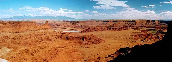
Particularly liked Dead Horse Point and the contrasting turquoise evaporation ponds!
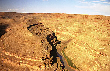
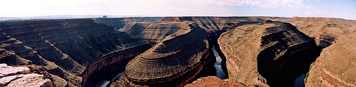
Just after Mexican Hat on our way to Moab, our base to explore Dead Horse Point, Arches and Canyonlands, we came upon Goosenecks State Park. The short detour is rewarded by the most impressive sight of the San Juan River, 1000ft below, looping around huge mesas in an "extended meander" - it flows six miles while only advancing one mile west!
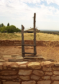
The partially restored ruins of pre-Colombian Pueblo (Anasazi) Indian buildings here include a reconstructed ancestral kiva - possibly the only way we would be able to see inside one of these ceremonial buildings. The Anasazi flourished in the south west around 900A.D. Their original dwelling places were below ground but later they began to build homes above ground. The original homes were not abandoned, however, and some became the ceremonial kivas.
The kiva is entered by descending a sturdy ladder. Inside it is very cool and, though rectangular above ground with a low wall and flat roof, the interior is circular with a ventilation shaft and an oval pit. The pit could have been a fire pit perhaps.
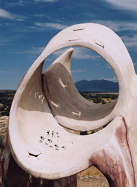
On the edge of this peaceful site is a Sun Marker sculpture which replicates prehistoric archaeoastronomy sites found in the south west USA. The people on this site used such devices to chart the passage of celestial bodies across the sky. For an agricultural people it may therefore have enabled them to understand the timing of the seasons and thus when to plant and harvest crops.
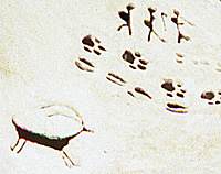
Antelope and human cut-out shapes allow the sun to shine through onto the inner surface of the spiral sculpture. On the lower surface animal prints, human figures and another antelope allow the light through to fall beneath the sculpture.
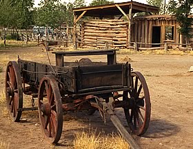
Bluff was a pioneer town settled by Mormons. The fort consisted of a square of 40 or 50 log cabins whose doors and windows faced inwards onto the open square. The Barton Cabin is actually all that remains of the original Bluff fort which was built in 1880 when the first settlers arrived. With some care and reconstruction this would make an interesting pioneer site.
Moab is by far the nicest town we have visited so far (2005) - reminds us both of New England. Lunch at the Poplar Place - pizza and, as we are now out of the Reservation, a beer for those not driving! The Slickrock Cafe, where we lunched on a later day, is a highly recommended spot - excellent Mango Tango Salad and Dead Horse Ale! On our final morning in Moab we had breakfast at the Jailhouse Café (it really was the courthouse/jailhouse at one time). Eggs Benedict and ginger pancakes eaten outside in the shade as the temperature soars.
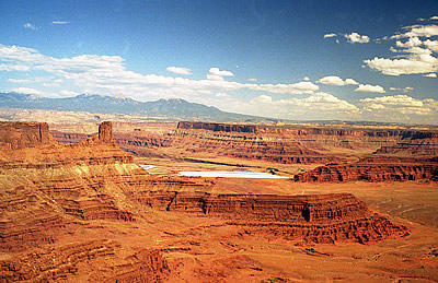
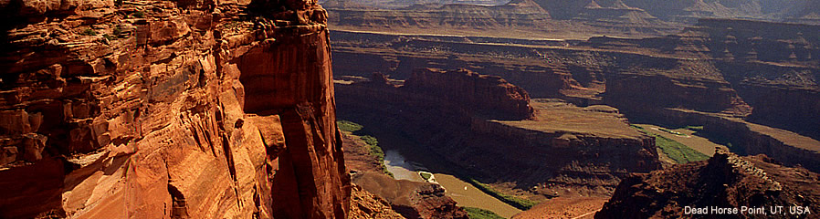
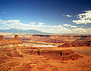
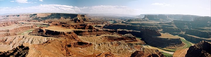
This is a fantastic canyon landscape: red rock walls soaring 2000 feet above the Colorado river and in the middle distance turquoise blue potash evaporation ponds. The views from the overlooks are truly spectacular.
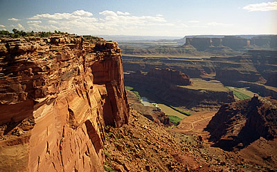
According to legend cowboys used to herd wild horses onto the mesa and corral them in with branches and brush at the narrowest point, which is only 30 yards. They would then choose the mustangs they wanted and just leave the rest to die. Presumably this would be reasonably quick in this desert environment with no available water, but it still seems rather a cruel thing to do - even in the Wild West!
The park sits on a thick (at one time maybe more than a mile!) layer of salt, laid down 300 million years ago when the area was coverd by an ocean. Over the following millenia organic material covered the area and was gradually compressed into rock. The huge weight of rock on the layer of unstable salt caused it to buckle thrusting some areas of rock up into domes while other areas sank. Wind, rain and ice formation - the weather eroded the rocks into the fantastic shapes which can be seen today.
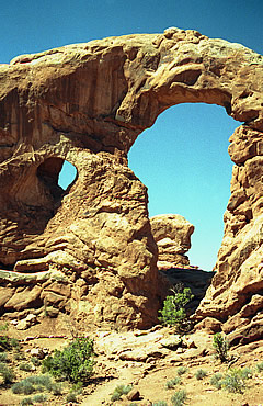
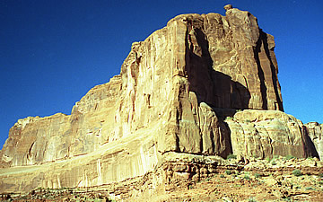
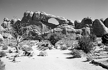
Boasting the highest density of natural rock arches in the world from a three foot opening (the minimum allowed to be called an arch) to the beautiful 306 feet long Landscape Arch. The park is another incredible landscape of red rock pinnacles and mesas as well as the famous arches, which appear to be on the sandy side of red - the colour's probably very much dependent on the position of the sun. The rock is mostly salmon-coloured Entrada Sandstone and buff-coloured Navajo Sandstone.
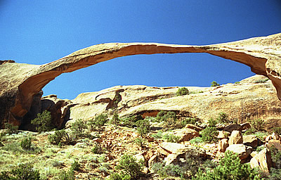
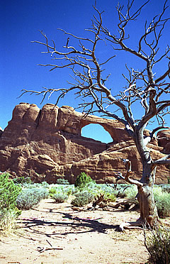
By 10a.m. it was already very hot so we decided not to overdo things! A short trail led us to Landscape Arch - in 1991 a slab of rock 60 feet long and 11 feet wide and four feet thick fell from the underside of the arch and it looks as though the remaining slender strip of rock may not remain intact much longer.
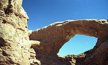
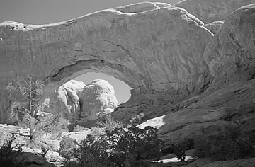
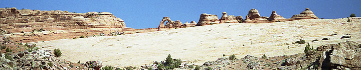
We went on to Delicate Arch then drove back to Windows and walked the trail to Turret Arch.
A fascinating and beautiful place.
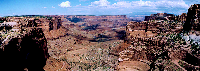
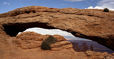
Canyonlands is yet another stunning desert wilderness of canyons, mesas, buttes and pinnacles. Two rivers, Green and Colorado, have carved out the separate massive canyons. The park has few paved roads and the opportunities to explore on foot are limited - without proper equipment it would be foolish to venture into this wide open space. But the views are magnificent: huge red-walled broad canyons. First stop was Mesa Arch overlooking a vast rocky, canyoned expanse below.
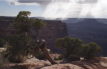
Then on to Upheaval Dome and a short hike to a view of the "meteor crater" - some fantastic canyon/butte views on the road. Late in the day it is now around 37°C and clouds are massing - looks like thunderstorms threatening in the distance.
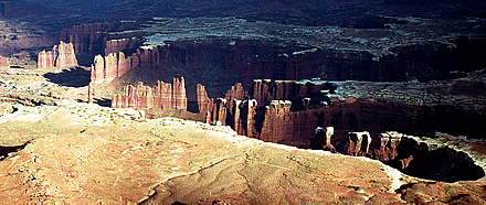
At Green River Overlook the vast plain below is punctured by the Green River canyon. Then our final stop was Grand View Point Overlook: rock pinnacles on the Green River Stillwater Canyon, the plain with its distinctive white rim on the canyon 1000ft below the overlook and the river 1000ft below that.