Three very different types of landscape: desert and salt flats in Death Valley, magnificent buttes in Monument Valley, and the deep Canyon de Chelly occupied centuries ago by Pueblo Indians and now holding some of the most impressive remains of their living places.
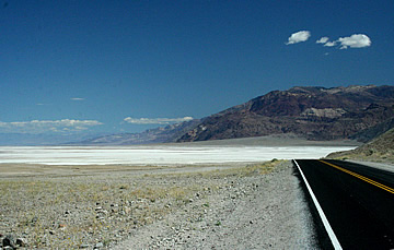
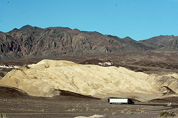
2010 Leaving Las Vegas early in the morning we drove to Death Valley via Shoshone which is just a few buildings and a gas station and a convenient place to fill up. So we approached Death Valley from the south and the landscape is almost immediately unbelievable. Mountain ranges east and west and a huge plain between with vast salt flats.
This immense National Park, 3.3 million acres, was given its name by a group of 1849 pioneers who thought it was a short-cut to California and barely survived their trek.
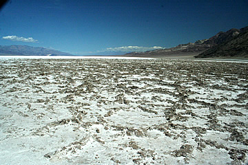
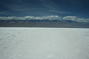
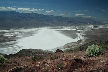
Our first stop (apart from photographs along the way) was Badwater Basin, the lowest point in the western hemisphere at -282 ft. We walked out onto the blinding white salt flats armed with water and shady hats!
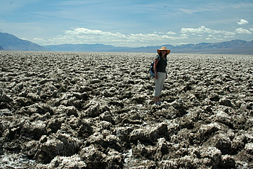
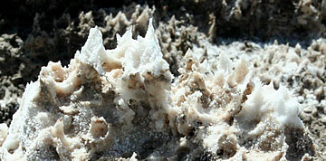
On to the weird landscape of the Devil's Golf Course - an extremely rough terrain of hard, sharp salt crystals - very difficult to walk on.
Randy, our guide at Toroweap, had told us of some lovely azure pools here and had given us directions but we failed to find them! Can't imagine water lasting too long in these conditions.
On to Furnace Creek for a beer before checking in - a very welcome cold Sam Adams in the saloon. Furnace Creek was originally Greenland Ranch, built on the site of two springs: Texas and Travertine. This was the water that the 1849 trekkers stumbled upon - it saved their lives. Alfalfa wa grown here as feed for the pack animals working at Harmony Borax Mine, also fruit and vegetables for the men; meat was also supplied from the ranch.
1500 date palms were also planted here in 1928 - an amazing sight in the desert.
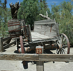
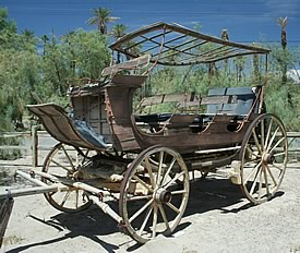
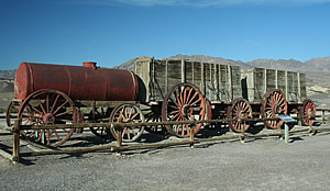
We had a quick look round the Borax Museum which has some interesting bits of machinery and stagecoaches. Also a wagon of the type many familes would have used to move west, extremely rough, little more than a plank box on wheels.
Mining companies exploited the deposits of gold, silver and borax in the area but the difficult conditions caused most enterprises to fail very quickly.
Later in the day we drove up to Dante's View, walking out to the furthest point of the ridge for the most magnificent view of the valley towards the western mountains, the Panamint Range, where the highest mountain is Telescope Peak at 11,049ft. Dante's View is part of the Amargosa Range and is much lower at 5,475 ft. Up here we saw some of the plants which manage to survive, including California poppies!
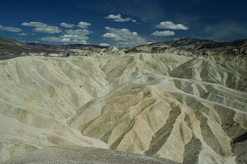
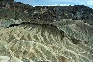
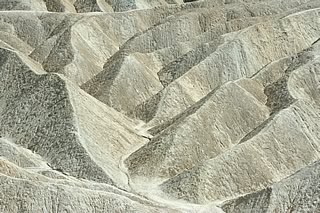
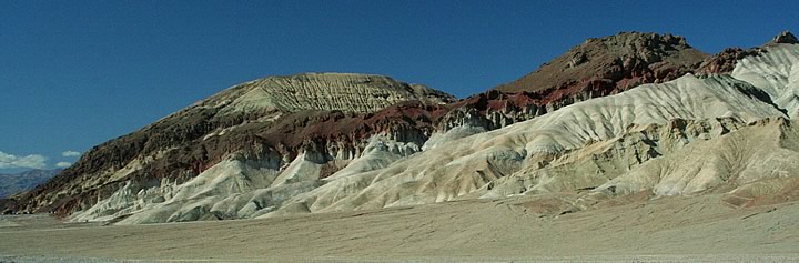
Lower down Zabriskie Point offers yet a different landscape: ridges and deep gullies created by infrequent but intense downhill rushes of water. It is quite unearthly and, though usually there are lots of tourists hopping off and on busses, well worth waiting for a quieter time to appreciate these fantastically eroded badlands.
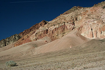
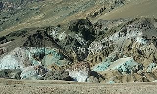
We made a brief walk into Golden Canyon with its colourful rock walls but didn't persevere too far before moving on to Artist's Drive and particularly to see the colourful rocks of Artist's Palette. Even later in the day the sun is so bright it makes them rather washed out though.
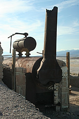
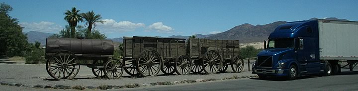
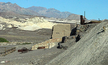
Borax was discovered in 1881 and Harmony Borax Works began to process ore three years later. At its height 40 men were employed here, using the famous twenty mule teams to transport the borax to the railroad town of Mojave 165 miles distant. At only two miles an hour this took 30 days!
The plant operated for only five years but it must have been one of the most horrendous places to scrape a living. The welfare of the men was of little concern; for instance, they didn't work through the heat of the summers, not for their health's sake, but because the borax won't crystallise out of solution above 120F!
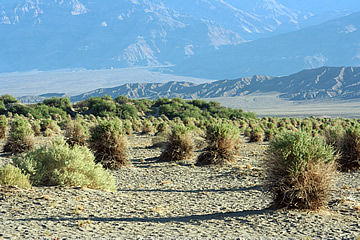
The Devil's Cornfield is another so-called "must see" but this area of corn shock-shaped arrowweed plants didn't do much for us!
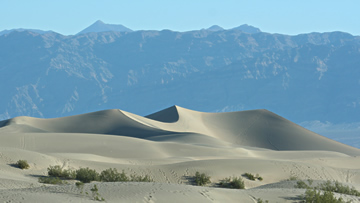
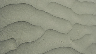
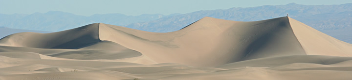
We left Death Valley very early in the morning in order to visit the sand dunes near Stovepipe Wells in a good light. These are classic, pure sand dunes, sculpted into beautiful wave forms by the wind. This was one of my favourite spots in Death Valley. We didn't mange to get to the mysterious moving stones on the Racetrack - next time!
We had an excellent breakfast at Panamint Springs Resort on the western edge of the valley before travelling on to Yosemite.
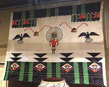
2005 On the way to the Canyon de Chelly in 2005 we wanted to learn something of the Hopi Pueblo Indians. We stopped at Cameron Trading Post which is supposed to be where Navajo trade but it didn't look like it. A huge 'Navajo' store: jewellery, artefacts, etc. but not our kind of place. On the road (still in Arizona) the landscape is mostly sage bush scrubby desert (heading for Chinle). In our quest for the Hopi we first stopped at Oraibi on Third Mesa - the oldest Hopi settlement - but it looked small and unfriendly so we didn't linger. On to the Hopi Cultural Centre below Second Mesa. Here, as elsewhere along the road, Indian pottery jewellery and Kachina dolls are for sale. The Kachina dolls are used as instructional tools for children and are carved from cottonwood which is very light. We didn't visit the museum but got information on visiting Walpi on First Mesa. On the road again a whirling mass of tumbleweed crossed the road - very reminiscent of old westerns!
The road climbs beneath cliffs of precarious rock into the first village Hano/Tewa; there are three villages on this narrow mesa.
A guided tour is the only way to see the village and photography is forbidden. The tour starts with an introductory talk and taste of blue corn bread.
There were only three of us in the group so it was very easy to talk to the genial and knowledgeable young Hopi man who acted as our guide. He was very good and gave lots of detail as we walked around his village, for instance on how the women cook bread in outdoor "beehive" clay ovens, building fires inside and regulating the temperature by removing a large stone from windows in the oven sides.
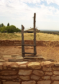
We were shown the ceremonial plazas with shrines and the six Kiva in the oldest village (late seventeenth century) Walpi, at the tip of the mesa - a stunning location high above the plain, a fine defensive site. Shrines with long feathers placed there in the morning are a "wishing for good things" place.
We were told how the peaceable Hopi made a deal with the Tewa - a warrior people - to fight for them, hence the location of the Tewa in the first village on the mesa, Hano.
The Hopi have fantastic runners: some run through the village in the morning to remove bad feelings, others run marathon distances - it's a traditional activity.
The houses are flat-roofed, stacked like a high rise, and the roofs are reached by long ladders - there are also spaces below ground level. The Kiva also have flat roofs and walls only a few feet high as the space is mainly below ground where ceremonial dances are performed in before the villagers - tourists and outsiders are not allowed into the ceremonies.
The Hopi are made up of several clans and each seems to have its own Kiva. All knowledge is passed on by word of mouth - nothing is written down. The knowledge of one dance (the snake dance) in our guide's clan was lost when the last expert died - none of the younger generation wanted to learn. Though another clan may have the dance, members of different clans are not allowed into the Kiva to watch.
Our guide practiced many traditional crafts including pottery-making and basket weaving, for which he walks 11 miles with his uncle to gather Yucca in 200lb loads (basically in a sheet on his back ). He also practiced the traditional herbal medicine for which he gathers plants in the plain. They grow maize crops on the plain and fruit.
Water can be a problem. It used to be brought up from the plain on foot, we were shown gaps in the village walls where the carriers entered and left to get down to the plain below. We were told that Peabody mine coal on Black Mesa and use a billion gallons a year to slurry the coal to far distant locations.
This windy, exposed, hot in summer, snow in winter, location is a harsh environment with incredible views and it was an immensely fascinating experience and a privilege to be shown around the Hopi villages.
We stayed in Chinle in order to visit the Canyon de Chelly - the town is not very attractive but the Holiday Inn was fine. This is on the Navajo Reservation so no alcohol to go with excellent fajitas and enchiladas!
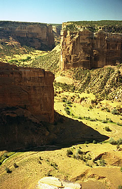
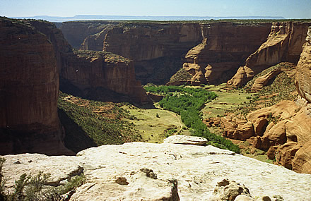
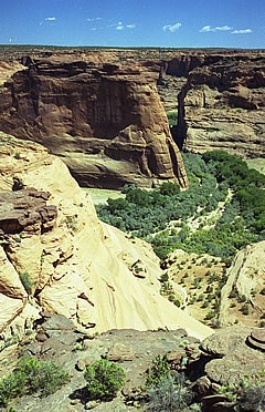
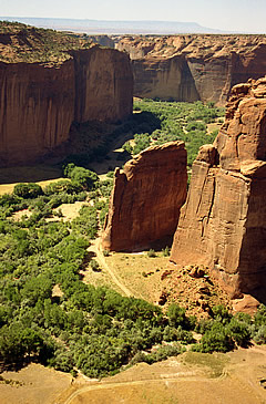
The canyon has a desert sand floor but the water table is high so there is quite a lot of vegetation, particularly cottonwood trees. There was no water in the river or stream beds and it was very hot, into the high 30s.
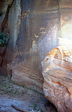
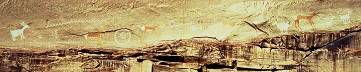
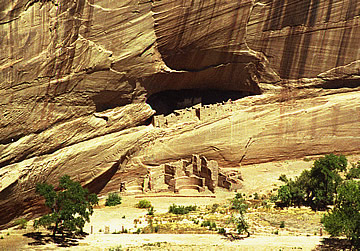
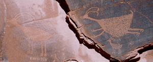
The canyon walls at the entrance are less than a man's height but soon rise to immense red cliffs on either side, the highest around 1000ft. This extremely bumpy ride is the only way to see the cliff dwellings, wall paintings (pictographs) and petroglyphs (pictures scratched into the rock) - of which there are many ranging from primitive human figures around 2500 years old to animals no more than 200 years old.
Horses only arrived here with the Spanish in the seventeenth century so this is a good way of narrowing the date of some of the pictures.
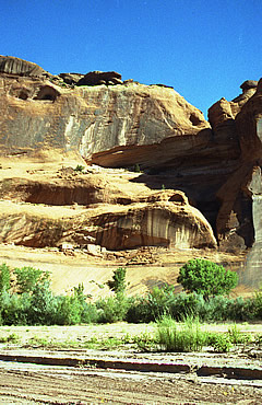
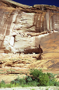
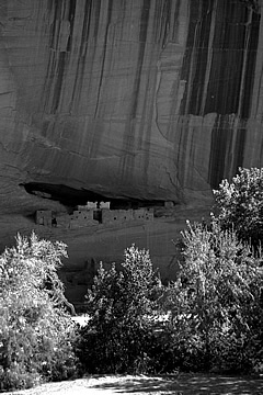
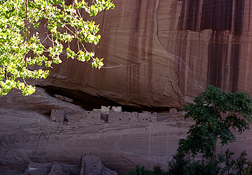
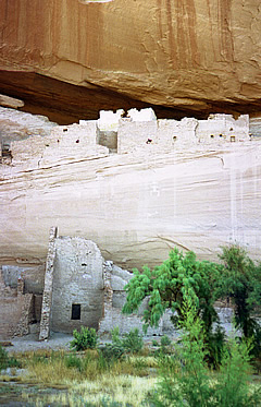
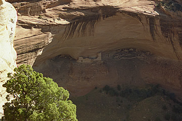
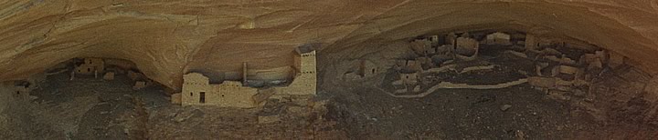
The primary motivation for visiting the Canyon de Chelly was the famous Ansel Adams photograph of the White House. In order to visit we hired a jeep and Navajo guide to show us both the Canyon de Chelly and Canyon del Muerte ($125) and started at 9a.m. on an incredibly bumpy drive into the canyon (we felt sorry for those who chose a guide using a flat bed truck!).
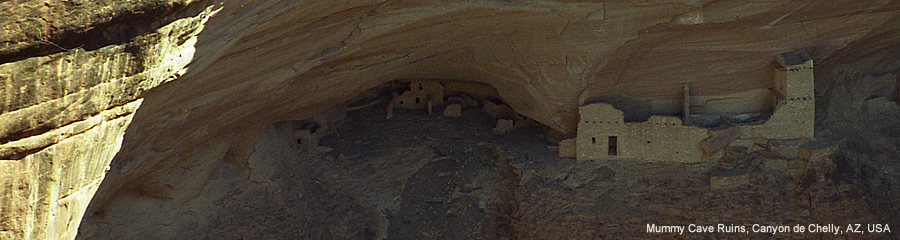
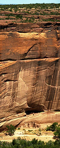
The canyon has evidence of occupation from around 2500B.C. Rock shelters were used by these people who found abundant food in the form of antelope and more than 40 types of plants. The White House is one of the Pueblo Indian structures around 1000 years old and with 80 rooms both on the canyon floor and built into the cliff face. The name derives from the long white wall in the cliff dwelling which is covered with white plaster. We saw many ancient Anasazi Indian cliff dwellings. The Anasazi are Pueblo Indians and were in the canyon around 1000 years ago.
Hopi used the canyon for grazing land between 1300 and 1600 but did not live there permanently.
The Navajo only arrived in the canyon around 300 years ago and brought domesticated animals - the Indian peoples did not have horses until they were able to obtain them from the Spanish invaders. What should have been a peaceful existence was later destroyed, first by inter-tribal warfare and war with the Spanish in the late seventeenth century.
In 1846, the canyon was claimed as United States territory by the military. An uneasy period of conflict and broken promises was eventually brutally terminated in 1863 when most of the Navajo were killed or captured, the hogans, orchards and sheep were destroyed and survivors forced to endure the infamous 300 miles Long March to Fort Sumner in New Mexico.
I was able to buy some very lovely turquoise and silver jewellery from the Indians here.
Later we drove the south rim of the canyon to various look-out points - binoculars were invaluable on the overlooks to inspect the many cliff dwellings. We had considered doing the White House Trail but it seemed rather too hot to attempt the two hour round trip and contented ourselves with the views.
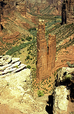
The final overlook is of a very impressive double column of red rock, towering above the canyon floor. This is Spider Rock, where Navajo legend has it that Spider Woman taught the Navajo to weave rugs. Wild horses roam here - we saw three rolling in the dirt at Spider Rock, and there are also impressively large-horned cattle around.
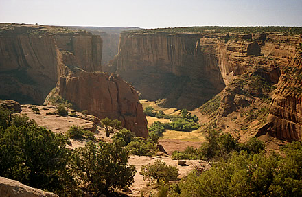
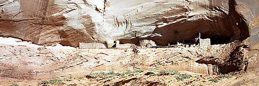
The following day we drove the North Rim on the Canyon del Muerte with some very memorable stops: Antelope House Overlook offers an excellent view of the layout of the buildings (named after the nearby wall paintings) and a great canyon view; Mummy Cave Overlook (where two mummified bodies were discovered during excavations in the 1880's): wonderfully preserved ruins, high in two huge smooth caves said to have been occupied for over 1000 years until 1300 and consisting of 80 rooms including 3 kivas; Massacre Cave Overlook: little more than a ledge but according to Navajo legend a Navajo woman grappled with a soldier and the pair fell to their deaths, hence the place is called "Two Fell Down" - the "massacre" relates to a Spanish military expedition which attacked in response to raids on Spanish settlements.
As Frommer's says " It's hard to imagine narrow canyons less than 1,000 feet deep being more spectacular than the Grand Canyon, but in some ways Canyon de Chelly National Monument is just that".
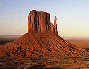
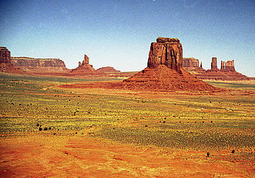
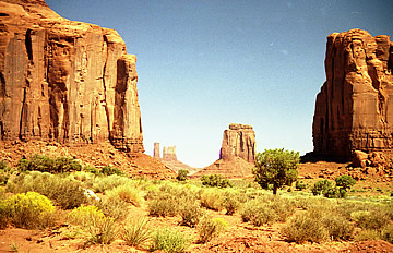
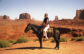
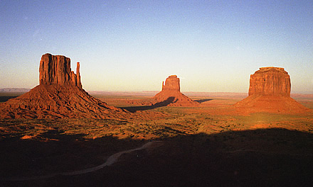
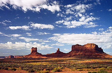
From Canyon de Chelly we travelled north to Mexican Water Trading Post then west via Baby Rocks to Kayenta where we were staying for visits to Monument Valley. Already some wonderful landscapes unfolding. We arrived early afternoon which was excellent timing for our first visit to Monument Valley. This is an impossible landscape to describe - the scale is enormous and the contrast - the buttes rising steeply from the desert floor - is what makes it so impressive.
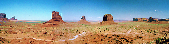
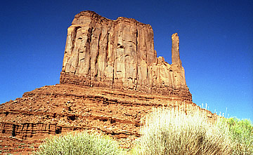
I had been very much looking forward to this visit - a landscape I knew almost intimately from the westerns my dad liked to watch, and one that I had always wanted to visit. This is quintessential "Wild West" - stunning! We decided to do the 3.2 mile walk around West Mittten. NB: sign the book at the visitor centre to say that you are taking the walk and sign out when you return.
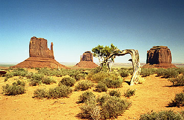
It was mid-afternoon and still very hot - around 35 °C - but we made sure we took plenty of water and sunscreen, though I foolishly did not have a hat. The trail out to West Mitten is well-marked, although the 0.2 mile marker doesn't seem to be in the right place! The views are fantastic with some very strategically placed dead trees for added effect!
We reached the halfway point quite easily, though as soon as you drop below the rim of the valley the temperature goes up and it must have been well over 40 °C. Rounding the West Mitten, this furthest part of the trail does not go right up to the butte, and the number of trees is even less than on the first part of the trail so shade is very limited. I definitely began to feel the strain - the walk itself is not difficult but the heat is unrelenting. I took advantage of every bit of shade and sipped water.
The final third was, for me at least, deadly. We lost the trail twice - the route at this point is not at all well-marked. The first time we lost the route we recovered it quite quickly but the second time it took some wide casting about and calm consideration to decide which way we should go. There are two problems here: the first being the poor route marking and the second the fact that on walking into the valley you lose all points of reference on the rim. The final climb out was tiring - this is not a walk to be trifled with! Nevertheless, highly recommended for the close-up encounter with the fantastic landscape.
I was rather tired so stayed at the end of the walk in the shade while Andrew fetched the car. While waiting I talked to a girl who was a travelling dentist, treating Navajo on the reservations. She told me that the original source of dispute over land between the Navajo and the Hopi was that the government promised the same land to both tribes - why doesn't that surprise me!
The following day we had organised a guided tour with a Navajo Indian ($90) in a flat bed 4 wheel drive fitted with quite comfortable bench seats. The going to begin with was quite rough but mostly OK, easier than Canyon de Chelly, but glad we did not try to drive ourselves.
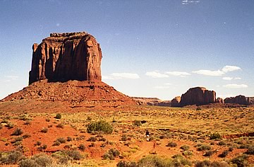
Fantastic scenery and an excellent tour seeing the different rock formations, pictographs and family hogans (only six or seven families live in the valley). John Ford Point where the first film cameras were set up for "Stagecoach" is on every tour!
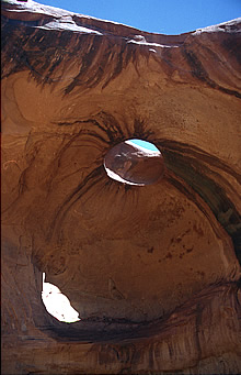
There are window and arch rock formations: Eye of the Sun and Ear of the Wind and at one point - Moccasin - there was a Navajo flute player in a huge cave (hogan-shaped) - maybe it was staged but it was incredibly atmospheric. Up to this point we'd been alone in our wanderings but here we came upon a group of tourists being encouraged to try Indian dances - very undignified!. On the way out we came upon a trail of oil and water and eventually an abandoned car - very glad we organised our own tour!
The burgers come highly recommended at the restaurant here - I had the "Michael Horse" which was the only 4oz on the menu - all the rest were 8oz, and of course the view is unbeatable.
Later in the day, around 6pm, we returned for sunset making a quick visit to Gouldings Lodge where there is an excellent small museum with old trading store and movie-related stuff plus John Wayne's Captain Brittles' cabin from "She Wore a Yellow Ribbon".
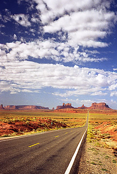
The following morning we drove out on 163 - the views back to Monument Valley are stunning - this would be a great road to arrive on!