Stunning slot canyons and a peaceful stretch of the mighty Colorado below Lees Ferry.

We stayed at the Marriott Courtyard as being the best of a poor selection in this area. We were pleasantly surprised that halibut and fries is on the evening menu and it was excellent. We found throughout this trip that "fish and chips" has been discovered in the US and was available right through to the west coast. The Marriott didn't do food at lunchtimes and the choice in town is again not great. However, this is just a base to see some magnificent country.
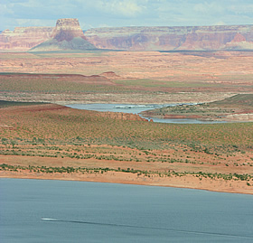
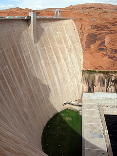
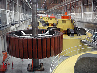
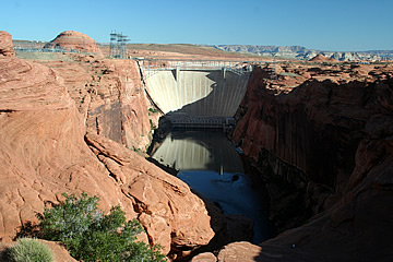
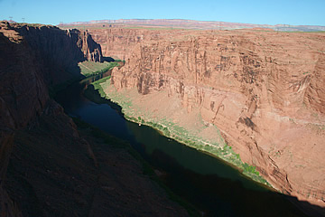
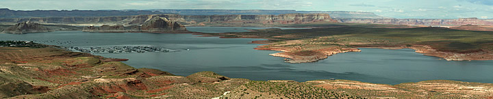
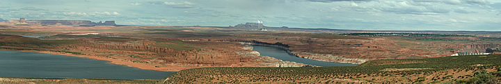
Near Page is Lake Powell and the impressive Glen Canyon Dam. We went on one of their guided tours, very interesting and not too long, going down to the top of the dam, then further down to the turbine hall (seen through glass).
The dam was built to allow irrigation of the desert from the lake, which stretches 186 miles back up the Colorado River, and to generate power. Apparently it took 17 years to fill the lake! To stop the massively powerful water damaging the run-off tunnels it is bubbled.
Down at the base of the dam is a vast lawn!
The land originally belonged to the Navajo Nation who swapped it for land in Utah. Begun in 1956, it was ten years before power was first generated. Concrete was poured non-stop for over three years for the dam and power plant.
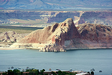
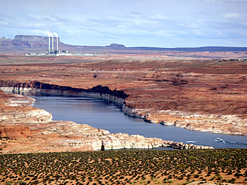
Though impressive in size, the lake could only be created by flooding the, by all accounts, magnificent Glen Canyon. The environmental movement was very much in its infancy at this time and building the Glen Canyon Dam was very much a trade-off for those such as the Sierra Club hoping to preserve some of the magnificent scenery elsewhere. Congress made a decision not to build more dams but to generate power from coal-fired stations instead and the Navajo Generating Station just south of Page burns coal from Black Mesa and pumps water from the lake to Phoenix.
These projects are the only reason that Page came into existence and survived.
Across from
the Marriott is an excellent place high above the river from which to see the dam.
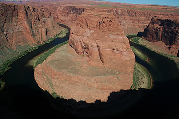
A few miles further downriver is Horseshoe Bend - a classic meander of the Colorado River. A hike of under a mile from US89 brings you to the overlook, about 1000 ft above the river. A highly recommended little side-trip.
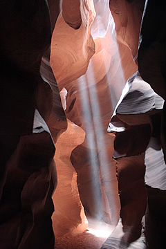
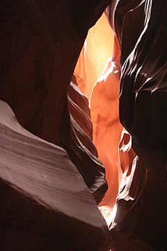
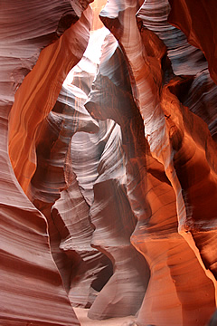
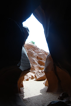
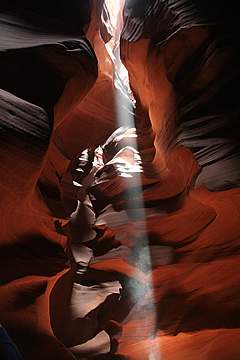
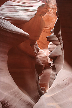
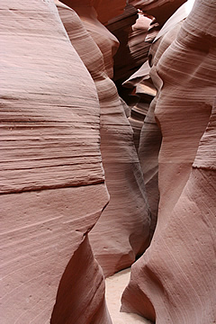
 Upper Antelope Canyon entrance
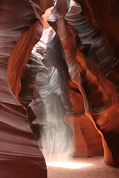
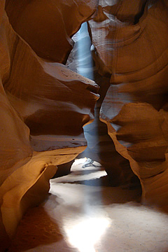
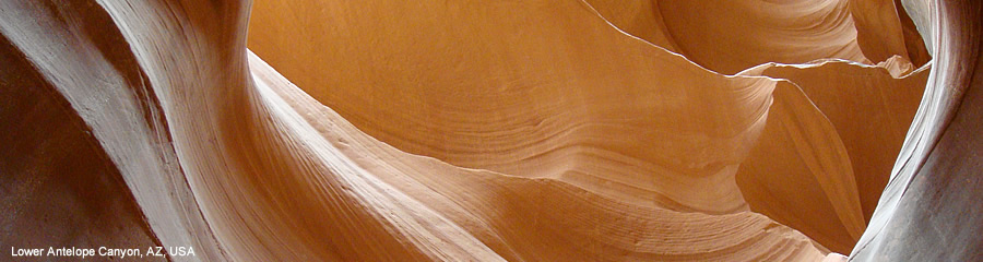
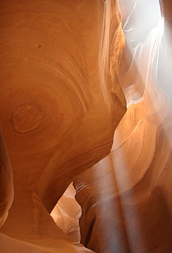
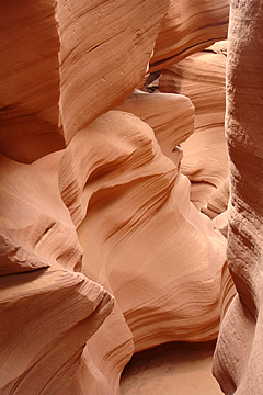
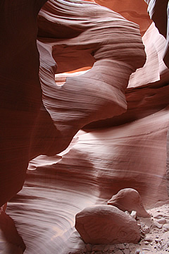
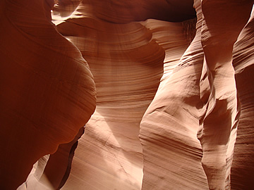
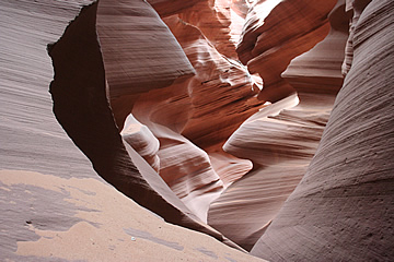
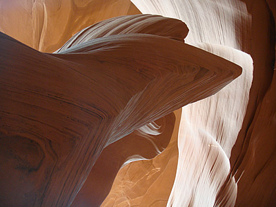
Draining north-west into Lake Powell, Antelope Canyon is reason enough alone to visit this area. Upper and lower sections of the canyon can easily be visited with Navajo guides - the canyon lies within the land of the LeChee Chapter of the Navajo Nation.
The canyon is formed from soft Navajo Sandstone due to water action. The resulting slots with their swirling colours are amazingly beautiful. But they can be deadly: the same flash floods which form them have killed unwary visitors.
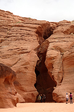
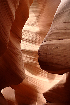
We drove out to the parking lot to get permits for Upper Antelope Canyon and just caught the start of the 11 o'clock tour - $25 each for a guide and $6 each for the permit, so not cheap. We wanted this particular time as it has the best light for photographs inside the high and narrow slot canyons.
A rather more hair-raising than necessary four wheel drive over sand to the canyon entrance. There were lots of tourists here; apparently it's always like this, but the guides are really good at getting people out of the way of the precious photographs.
We were a group of about ten with our guide Josh who was really nice and helpful, answering any questions we had, taking shots of interesting features at odd angles created by tricks of shape and shadow: bear and jackal for instance. The Navajo name for Upper Antelope Canyon is Tse bighanilini meaning "the place where water runs through rocks."
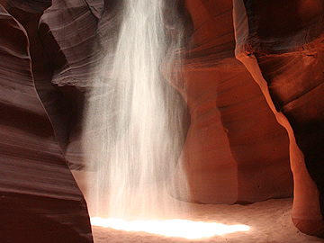
The canyon isn't very long and you could probably walk from the entrance to the end in less than ten minutes, if you didn't stop to take photographs. The light inside is beautiful, all soft amber hues, and the guides throw sand into the air to make the shafts of light penetrating the narrow crack in the roof stand out.
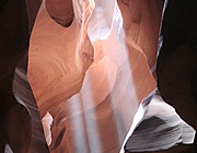
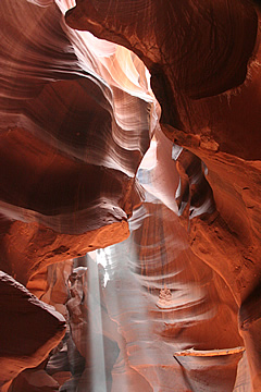
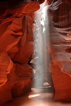
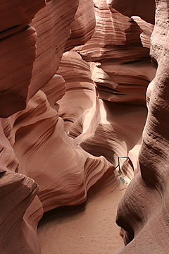 Going down into Lower Antelope Canyon.
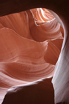
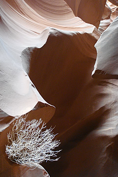
Everyone goes to the Upper Canyon, but only a few seem to visit the equally beautiful Lower Canyon. This does have great advantages for those who do. The peace and vast beauty is not spoilt by hordes of tourists and you can take your time over the photography.
We'd already decided we wanted to visit both upper and lower canyons so we went on to Lower Antelope Canyon, whose Navajo name is Hasdeztwazi or "spiral rock arches". We weren't really expecting much here - otherwise why do so few people come? But it was wonderful.
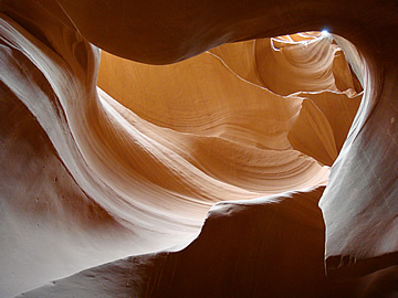
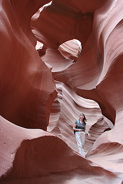
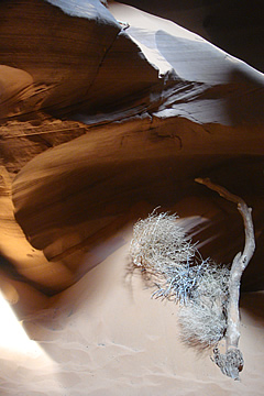
We were the only visitors here with our guitar-playing guide. He said barely a word, so no helpful info, but led us over the sandy terraine to the entrance to the canyon which is through a crack in the ground. We scrambled down and entered the most amazing space. It is astonishingly beautiful.
We climbed down quite a long way, sometimes on ladders or steep wooden stairways, working through very narrow passages, the sandy colours shading into soft lilac, swirling in curved striations. Our guide kept just ahead of us, always out of sight but softly playing his guitar - magical.
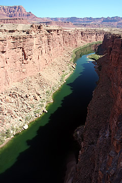
US89 carries on south out of Page to drop abruptly down off the mesa onto a vast plain. A little further on US89A branches off to Navajo Bridge which crosses Marble Canyon.
On the western side of the bridge a detour north leads to Lees Ferry (with an outrageous $15 fee to park in the area!) - the disembarking point for the gentle float trips coming down from just below the dam.
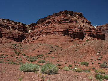
A short way along Lees Ferry Road is the entrance to Cathedral Wash - here it is all red rocks but further in hikers say it turns white.
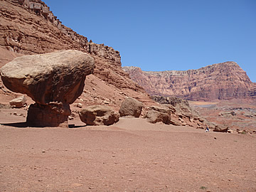
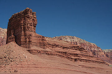
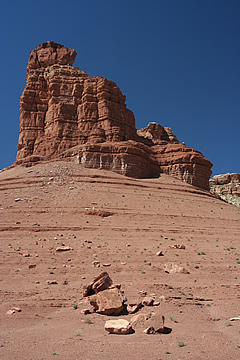
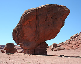
A large - very large! - standing rock can be seen at the side of the road. An information board tells how the boulder fell from the cliff above thousands of years ago, since when about 6 ft (1.8m) of the softer ground below it has eroded away.
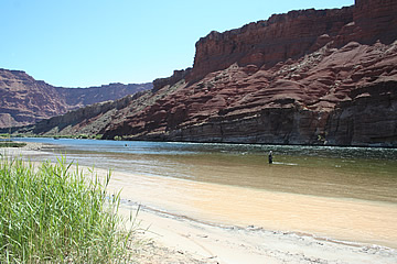
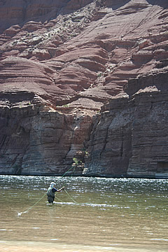
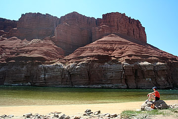
At the actual Lees Ferry landing area it's swarming with tourists, but just down river it's an extremely pleasant spot, popular with anglers and those looking for peace and quiet, with the huge Colorado River rolling by on its way to the Grand Canyon.
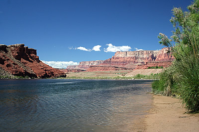
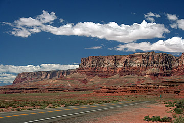
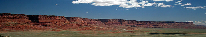
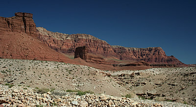
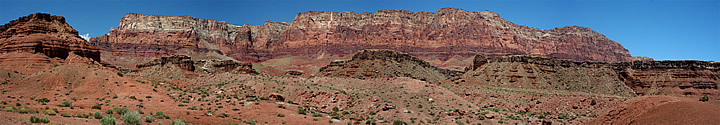
Down river the Vermilion Cliffs recede into the distance. We were continuing on 89A west to Las Vegas and the road runs dead straight below the deep red cliffs unitl it hits the Kaibab Mountains and starts to climb - we stopped here for some magnificent views back east to the Vermilion Cliffs.